Global Marine Infratech Pvt.Ltd.

Equipments

Hydrography

LogiHub
Bathy 500 Echosounder

The Bathy-500HD Survey Echo Sounder provides a high-contrast thermal chart record complete with alphanumeric annotation of important parameters such as geographic position, depth, speed of sound and offset for draft/tide. Real-time viewing of all parameters is provided to the user via front panel liquid-crystal display.

LogiHub
Ceeducer Echosounder

Ceeducer Echosounders are high definition, high ping rate devices using traditional standard analog transducers coupled with powerful processors driving advanced bottom tracking algorithms. It is designed to give the small-boat surveyor a compact, rugged and portable “1-Box” survey solution. It is used for surveys in river, lake, port, harbour and the coastal marine environment.

LogiHub
DGPS C-Nav

C-Nav systems deliver precise point positioning (PPP) with worldwide accuracy of better than 5 cm horizontally and 15 cm vertically. Unlike traditional DGNSS technology, our systems do not suffer from spatial decorrelation, thus providing the same accuracy anywhere in the world.

LogiHub
DGPS Leica GS15

Built for harsh environmental demands, the Leica GS15 features protection against dust and water up to IP67 rating and can function even after a 2m survey pole fall or a drop to the ground of up to 1m. This reliable GNSS receiver comes with features to improve the accuracy of your data such as SmartCheck and SmartTrack and the integrated web server allows you to configure your data logging.

LogiHub
DGPS Trimble Marine BX992

The Trimble Marine BX992 GNSS Heading Receiver is a dual-antenna GNSS receiver offering precise heading capability and and multi-frequency support for all known constellations. Additionally, with support for MSS L-Band, Marinestar or RTX services, the BX992 delivers position without the use of a base station.

LogiHub
DGPS

This type of DGPS is an external waterproof GPS receiver with integrated antenna for applications in the open air, at sea or on vehicles.
It has an outstanding high sensitivity Marine GPS receiver. Its excellent performance accurate, reliable and useful aid to your positioning pursuits. It also has high sensitivity for weak signal operation without compromising accuracy.
It receives FREE broadcast signals from the Low Orbit Global Positioning System (GPS), a satellite-based transmitter which emits ranging/satellite information/high precision time signals that the dgps receiver can use to determine positions and time.

LogiHub
Echo Sounder MK III (Odon)

The Echotrac MK-III offers the choice of either a high-resolution thermal paper recorder or a full-sized high bright colour LCD chart in interchangeable module format. Both high and low channels feature frequency agility, enabling the operator to precisely match the transceiver to almost any existing transducer. This ability minimizes near-surface noise caused by transducer ringing while increasing echo return strength. The MK-III is capable of both shallow and deep-water operations and features unsurpassed interfacing flexibility with four serial ports and high-speed Ethernet capability for maximum efficiency.

LogiHub
Echo Sounder MK-II (Odon)

Specifically designed for work in less-than-ideal circumstances on small survey boats and inflatable watercraft, the HYDROTRAC MK-II offers compact portability and the confidence a proven product survey industry. It is completely waterproof and comes equipped with advanced features of an ideal echo sounders.

LogiHub
Multibeam R2 Sonic 2020

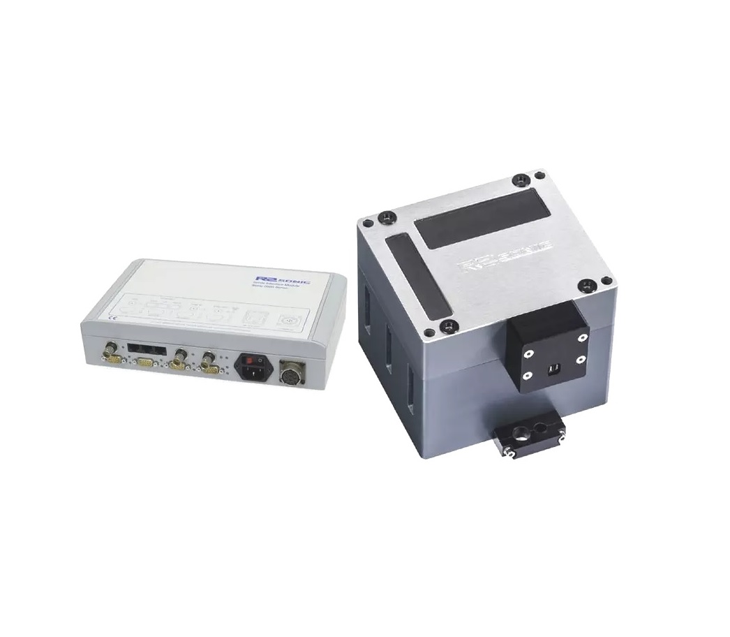
The R2 Sonic 2020 is the low-cost entry level broadband Multibeam Echosounder for shallow, highly portable, easy to use unit makes survey operations efficient and fast. Ideal for river systems, riparian, estuaries, reservoirs, and lakes.
The Sonic 2020 can be upgraded to Ultra High Resolution (UHR), providing extremely narrow beam widths at 700kHz operation. The narrow beam widths at 700 kHz make this option invaluable for detail pipeline inspections, cable laying operations, archaeological wreck surveys or other micro bathymetry applications.

LogiHub
Multibeam Reson 7125

Reson 7125 measures up to 511 discrete soundings equally spaced across the wide 150° swath. This sounding density combined with real-time roll stabilisation, high accuracy and robust bottom detect provides maximum performance and efficiency in all acoustic environments.
Ideal for underwater vehicles or rapid deployment onto survey craft, Flexible upgrade options for increased efficiency, Wide swath coverage of 150° to a maximum range of 500m to reduce survey time, Optional 210° swath, Water column data.

LogiHub
Side Scan Sonar

The CM2 digital towfish is the instrument that acquires the data from which the sonar image is derived. It is towed, and provided with power and digital telemetry services, by a reinforced or armoured 2-conductor tow cable.